Business & Tech
Fly Through 3D Fairfax with New Simulation Tool
The county's Virtual Fairfax project allows users to explore a changing county and city.
Ever wanted to take sunrise soar through Fairfax City? Or how about the entire county? With a new 3D simulation modeled after Google Earth and with the first-person flight powers seen in Second Life, anyone can do just that.
Fairfax County Department of Information Technology unveiled a comprehensive 3D simulation of the entire county over the summer as a new tool for residents to observe its development. This came about as a new response to an old need and the cooperation between the county and a local software developer.
Virtual Fairfax somewhat resembles Google Earth–a full 3D version of Google Maps, except specifically focused on Fairfax County. Its primary use is to help groups dealing with real estate and concerned residents better plan how Fairfax will look in the future.
Interested in local real estate?Subscribe to Patch's new newsletter to be the first to know about open houses, new listings and more.
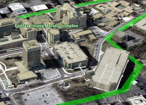
Operating through a web browser, users can view the county–including 3D representations of important buildings, from all angles and under various conditions. Users can take a sunrise tour down Main Street in downtown Fairfax City. Developers change, remove, and add buildings to get a clearer vision of development plans. Residents can see if these plans will affect the view from their homes or cast shadows on them.
Users can also embark on pre-programmed historical tours and views of county landmarks, like the Mixing Bowl and the National Air & Space Museum Steven F. Udvar-Hazy Center.
Interested in local real estate?Subscribe to Patch's new newsletter to be the first to know about open houses, new listings and more.
Click here to check it out.
The program will also develop along with Fairfax. The county plans to update the photos that comprise Virtual Fairfax every two years from 2011 onward. On top of updating buildings as they change, the county will make sure to render more parts of the county in 3D.
As of now only the major centers like Tyson's Corner, the Dulles Corridor, the Judicial Center, the Government Center, and a few more locations are in 3D. The county is open to suggestions on which areas need more detail but will stick to major business centers.
The plan for Virtual Fairfax started in 2008 with the county's Land Use Accessory and Command Committee.
"People wanted to see the county provide land use information more readily," said GIS and Mapping Services Department supervisor Mike Liddle. According to Liddle, one of the committee's recommendations included the ability to proposals for the city in 3D.
When looking for software that could do this, only one product met the requirements the county was looking for–Terra Explorer from Skyline Systems, a former computer game developer based in Chantilly.
"It was really one of the only products on the market at the time that allowed us to put in 3D buildings," Liddle said.
Skyline hosts most of the information for the terrain, images, and 3D buildings on their servers.
"[It] took away some of the burden that we would have here in the county," Liddle said.
The images that make up the map as of 2010 are the county's own 2007 and 2009 imagery. They built the 3D structures from oblique imagery and pictometry–taking pictures of every location in Fairfax County from at least four angles, and then put all this information into Terra Explorer to create their own version of it.
Skyline is pleased to work on something for their home turf for once after working with military intelligence and various international contractors.
"It's always good to have your local county as a customer," said Skyline strategic development vice president Ira Marcus. "We're excited with what they've done. We think it's a good move for the country as far as providing a service back at county residents and attracting business."


